
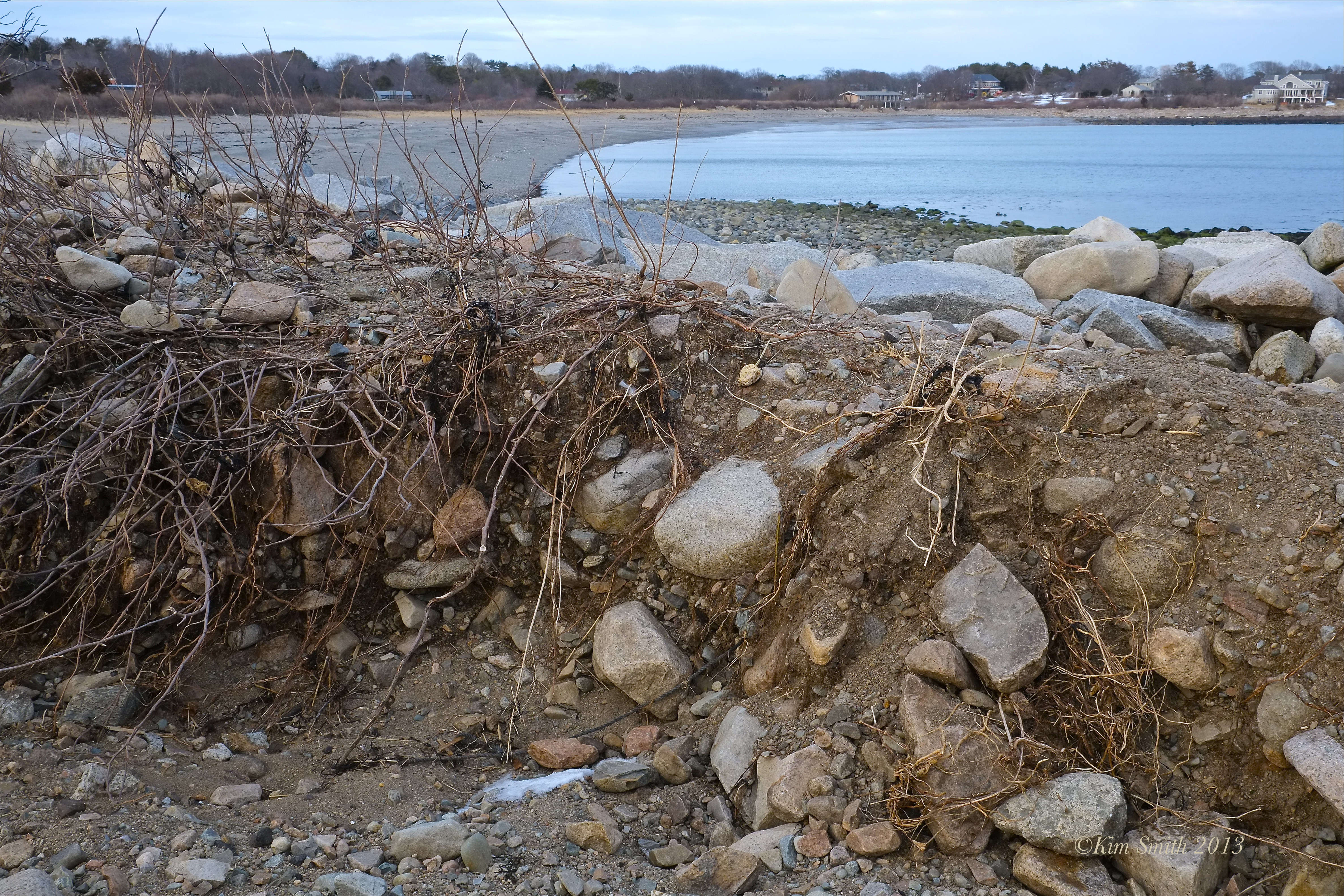
The narrow strip of land that separates freshwater Niles Pond from the Atlantic Ocean was severely damaged during Blizzicane Nemo.


In several places along the footpath, there are cuts clear through the granite dune and a sandy beach is forming on the Niles Pond side. Shrubs, wildflowers, and ground covers that help retain the sides of the causeway have been uprooted and washed away.

To read more about what makes this narrowest strip of land dividing Niles Pond and Brace Cove so unique, see JoeAnn Hart’s beautiful story about Niles Pond.

Niles Pond and Brace Cove Footpath Storm Damage
Spread The GMG Love By Sharing With These Buttons:
Related
Published by Kimsmithdesigns
Documentary filmmaker, photographer, landscape designer, author, and illustrator. "Beauty on the Wing: Life Story of the Monarch Butterfly" currently airing on PBS. Current film projects include Piping Plovers, Gloucester's Feast of St. Joseph, and Saint Peter's Fiesta. Visit my websites for more information about film and design projects at kimsmithdesigns.com, monarchbutterflyfilm.com, and pipingploverproject.org. Author/illustrator "Oh Garden of Fresh Possibilities! Notes from a Gloucester Garden."
View all posts by Kimsmithdesigns


wow, very close to each other
LikeLike
It really is extraordinary. I hope the worst of the storm season is over.
LikeLike
I have never seen the land separating Niles Pond and Brace Cove (the ocean) look so fragile. With more storms likely this winter, I hope Niles Pond does not become “Niles Cove.”
LikeLike
It’s just a matter of time Kim till the ocean reclaims what was once hers. I am amazed every time I see a pic of the creek at Good Harbor Beach and see how much the path of it has changed. I have always thought that when they removed the pilings for the 2nd bridge that it had something to do with it. The 2 rocks you see in all the pics of the creek used to be in the middle of the creek at one time and we would swim out to them at high tide and climb up on them.
LikeLike
I found JoeAnn’s article so interesting because she talks about how Farmer Niles fortified the causeway with granite. Very interesting about Good Harbor too, will look at it differently next time I am there.
LikeLike
Very alarming to see. Sea levels rising as they are, with seas along the East Coast from North Carolina to New England rising three to four times faster than the global average, it is only a matter of time as Fred said, before Niles Pond will become Niles Cove.
LikeLike
Joey is wise to “sticky” this to the top of the blog. It’s a serious situation. In the past, I’ve heard comments from Eastern Point residents about how difficult it is to get DEP permission to reinforce the berm (if that’s the correct term). These days you can’t just dump material near the water without going through the process.
LikeLike
Im still walking and birding often along the remains of the berm, but the going is treacherous. The damage from the combined effects of nemo and the fall hurricane is just stunning. I do hope somehow it will be repaired.
caroline Haines
LikeLike
Thank you Caroline for writing. I am hoping, as did Farmer Niles, we will be able to reinforce the berm for another hundred plus years. Each year, Niles supports thousands of migratory birds, and wildlife the year round. Although the sea may someday reclaim the pond, it would be in the best interest of the community and wildlife to preserve the pond for as long as is humanly possible.
LikeLike
Knowing Eastern Point, I think Niles Pond will be preserved and the berm reinforced.
LikeLike
Here’s the lay of the land:http://www.facebook.com/photo.php?fbid=423932251026172&set=a.115850935167640.27287.109638072455593&type=1&theater
LikeLike
Thank you so much Fred for posting this map-it shows perfectly just how very narrow is the footpath between Niles and the Atlantic.
LikeLike
That’s a shame. I well remember when the pond nearly became a part of Brace Cove. Because of that storm, the berm or granite dune as someone so aptly called it above, was built. Since it is on private land, it will be unlikely it is rebuilt unless the residents of Eastern Point foot the bill for it and it will probably be prohibetive at that.
LikeLike
I think it’s a crime that there is basically no public access to this area. Why should just a few get to enjoy the beauty of the cove? There should certainly be a small parking area (2-3 cars) carved out possibly taken by eminate domain so that the public can enjoy this area.
LikeLike