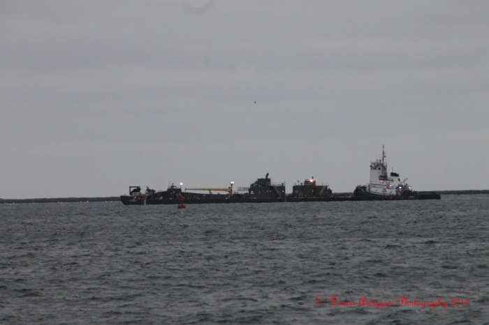
Good morning to all: Does anyone know what this is out in the harbor? It came in yesterday.
Spread The GMG Love By Sharing With These Buttons:
Related
Published by Donna Ardizzoni
Ardizzoni Photography, Business Manager, Grandmother, love living in Gloucester, love to swim, kayak, walk and of course take pictures. Our company does computer networking, Office Management, Medical Billing, transcription, networking software updates and virus protection
View all posts by Donna Ardizzoni


Looks like a sand dredge.?
LikeLike
Thank you for the information
LikeLike
According to marinetraffic.com, it is a tug, no name given, with a destination of Portland. No information about the barges. If I had to guess, I’d say they are carrying liquified something or other.
LikeLike
Great information and thanks for the website
LikeLike
I forget to check that website to check boats passing by. That tug out there now is the Siberian Sea which belongs to a set of tugs, Davis Sea and Lincoln Sea. They are based in New York harbor (tugster draws them a lot). A friend of mine is on Lincoln Sea which looks to be all the way up the Hudson at Albany. They seem to push a lot of double lined barges with a gazillion gallons of heating or diesel oil from the Gulf of Mexico and pump out in Portland Maine and a dozen other places sprinkled up the coast. I’ll try to dig up a photo of the most amazing huge fish that John trolls for off the back when he is further south.
LikeLike
Looks like a fuel barge
LikeLike
Thanks for the reply
LikeLike
SIBERIAN SEA
Vessel’s Details
Flag: USA
Ship Type: Tug
Status: Anchored/Moored
Speed/Course: 0.1 kn / 0˚
Length x Breadth: 60 m X 16 m
Draught: 4.7 m
Destination: PORTLAND
ETA: 2013-02-08 09:00 (UTC)
They are supposed to be pulling into Portland right about now but looks like they will hang behind the dogbar breakwater until it stops blowing. The details are of the tug only. The website usually lists how big the barge is but not this time.
LikeLike
cool site, thanks for sharing that!
LikeLike
Thanks Rich and enjoy the storm
LikeLike
It is indeed fuel barges. I assume they will wait out the weather here. Compared to ships, barges tend to be shallow draft even loaded down to their marks. We have a basic problem here on the East Coast. Of course Gloucester is a very shallow harbor and even a small oil tanker could not come into our harbor. However actually no harbors on our coast have the depth and space to handle supertankers. They are stuck with islands in the Caribbean with steep sides down to deep water. Once, years ago when an oil port was being proposed for downeast Maine, I pointed out somewhat tongue in cheek that there was a good place with the necessary 70 feet at low tide. All we needed to do was finish the Sandy Bay breakwater and we had a tanker port. Crude could be pumped up through the town to refineries in Dogtown. My suggestion was not greeted with open arms (and they call me an obstructionist).
LikeLike
Thanks for the information
LikeLike
I noticed it this morning looking past Ten Pound Island , was wondering the same thing and thought it might have something to do with blizzard prep, I guess oil/diesel would qualify to some extent.
LikeLike
thank you and enjoy the snow
LikeLike
Dang – I was gonna guess tug for dredging…I don’t look ’em up – I just like to guess. (Tugs are my favorite boat)
LikeLike
Here in Michigan we call that a boat.
LikeLike
Thanks is really funny and thank you for the post
LikeLike