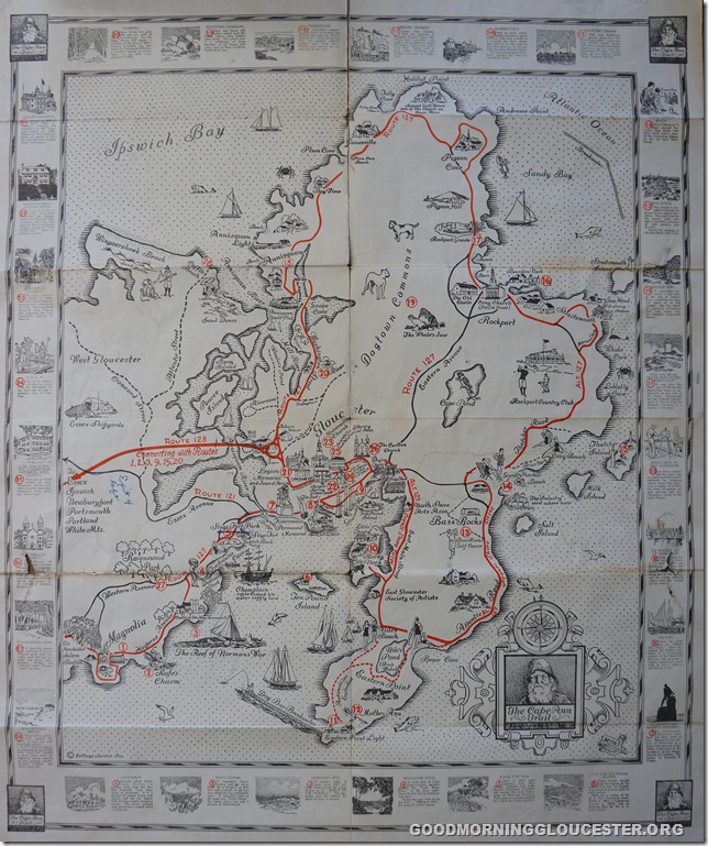
If you haven’t got it yet I can say without a doubt there is a clue on this page.
FOB Frank Ciolino brought down this old Visitor’s Guide map and I’ll be posting a different neighborhood photo each day this week. Look for clues to tell you when you think it was first published.

Spread The GMG Love By Sharing With These Buttons:
Related
Published by Joey Ciaramitaro
The creator of goodmorninggloucester.org Lover of all things Gloucester and Cape Ann. GMG where we bring you the very best our town has to offer because we love to share all the great news and believe that by promoting others in our community everyone wins.
View all posts by Joey Ciaramitaro


1930? Looks like it with the bathing suits the women were wearing at the beach.
LikeLike
The copyright date is in the lower right corner–1930, but this must be a later issue?
LikeLike
Five Pound Island is on the map and they didn’t start building the State Pier till 1937 so it has to be before then.
LikeLike
Route 121 was changed to Rte 133 at some point. I tried to research it, and only saw a reference to the 1920’s some time. I think that may be the clue, but I don’t have the answer for sure.
Tim/
LikeLike
I think it is a composition on a old tourist map of the 20-30 then reused with red mark highlights in the mid-50s-60’s time frame. Does not show the fish pier that coverered over five pound, notes the flake fish racks that were all over the water front and the gill net drying racks that stopped being used in the 60’s with the introduction of man made fibers. We use to dry all nets because if the natyual fiber twines used in making them, that was replaced with cotton tarred the, nylon then ,then poly.So the exact date is puzzling.
LikeLike
So what about rt 128? 1953 for the run to Grant citrcle via Senator A. Piatt Andrews Bridge. 1959 for the extension run to Main St. So how about between those two years.
LikeLike
I’m now rethinking. The native american and the pilgrim are engaging a “High Five” in the upper left corner. So this gets us to 1977!!
LikeLike
That’s a riot Bob – “High Five” – you forgot about Daniel Boone tv series or F Troop 65-67 ” How ! We”re the Hackawi”s .
LikeLike
I’m in suspense!
LikeLike
On the route 121 on map this was a State assigned numbering system in 1922 even numbers ran East – West Odd N-S . in 1926 the system was changed and reasigned State route numbers so routes 101-142 had been assigned to Odd ran East – West and even North – South. so 133 came about then.So when was the map Print ? most likely before 1926.
LikeLike
I thought the Rte 128 bridge was built after WW2. 1948-50?
LikeLike
Cant Be exact but it was some time in 1930 that my Grandfather Mons H Osterberg drew it We still have the original
LikeLike